
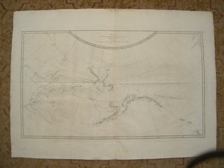
CHART OF THE NW COAST OF AMERICA AND NE COAST OF ASIA EXPLORED IN THE YEARS 1778 & 1779. THE UNSHADED PARTS OF THE COAST OF ASIA ARE TAKEN FROM A MS CHART RECEIVED FROM THE RUSSIANS [A VOYAGE TO THE PACIFIC OCEAN]
London: G. Nicoll and T. Cadell, 1784. Map. Plate 36 from the atlas volume of Cook, James; A Voyage to the Pacific Ocean: Undertaken, by the Command of His Majesty, for Making Discoveries in the Northern Hemisphere, published by G. Nicoll and T. Cadell; London, 1784. Writing engraved by T...... More